January 2024: ACER is excited to announce completion of all tree plantings in the Ganaraska River Watershed for the provincially funded Great Lakes Local Action Fund (GLLAF) project that kicked off last November at Sylvan Glen Conservation Area.
This region was chosen for this project because it has many streams flowing south into Lake Ontario, streams that are prone to flooding, especially in the urban areas built alongside them. In addition, the sewers that run under major town buildings are aging rapidly and are more and more at risk of failing as new developments are added, a story of many lakeside communities. Finding ways to reduce erosion and thereby also reduce flooding, is a key environmental objective in that region.
This project involved a year of field work with over 300 volunteers planting over 1000 native trees across six sites in Port Hope and Cobourg, in collaboration with three key partners: the Ganaraska Region Conservation Authority, Sustainable Cobourg, and the Town of Cobourg. The ten percent of trees measured at each site on planting day will become part of ACER’s Riparian Rangers monitoring program and the tree data collected will allow analysts to assess which species at each site were most successful, and which species store the most carbon and release the most oxygen, so essential for our survival! And, the seeds of all trees planted can be used to plant future forests!

Trees planted on kick-off day at Sylvan Glen Conservation Area, November 2022 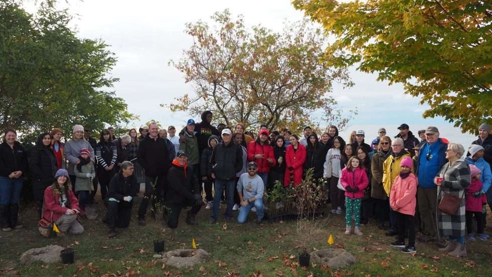
Getting ready to plant in Port Hope (Peter Huffman trail), October 2023
This project could not have been completed without the help of many key people. Pam Lancaster of the GRCA coordinated all of the planting events including procurement of trees and supplies, and selection of the sites (for example, Legion Fields in Cobourg that is near a major community centre and was sorely in need of more tree canopy). Sustainable Cobourg, headed up by President Gigi Ludorf-Weaver, fully supported Tovan Lew, their youth ambassador, in the recruitment and coordination of the volunteers. Tovan also designed the project’s logo. Then there was Jonathan Brown, a long-time ACER collaborator, who acted as the project’s liaison for all local coordination efforts with full support of the town of Cobourg. Also instrumental to the project’s success has been ACER’s Program Manager Dr. Sadia Butt who coordinated the entire project and also led all training on the proper tree planting and tree data collection protocols.
Community volunteers including students, town staff and councillors, and the general public also played a critical role in the project’s success. One planting event drew almost 80 volunteers, who came out on a very windy, chilly day in mid-October to help plant along the cliff edge of Port Hope’s waterfront trail, including the founder of the trail, Peter Huffman. And…volunteers didn’t leave empty-handed: all learned how to plant, mulch and measure trees, and how to identify the tree species they were planting, and also left with a better understanding about the critical importance of planting trees to help mitigate the impacts of climate change, knowledge they can apply to their own back yards and community green spaces.
It is especially exciting that this project is a first for ACER in that it has been digitally supported throughout, including our first-ever usage of drone technology to assist with tree mapping at the final site, St. Mary Secondary School/Chris Garrett Retention Pond in Cobourg. The Grade 11 student, Matthew, who flew the drone and captured the video (see below) was also able to obtain a formal drone license, and we hope to be able to work with him further to learn about other possibilities for drone use in our work. We also upgraded our GPS (geospatial positioning system) to increase the accuracy of tree mapping and had the opportunity to participate in a day-long workshop at Venture 13, a state of the art technology centre in Cobourg. Amongst other topics, the workshop included a presentation and discussion on the drone usage in the project and led to some great discussions and ideas for the future, for example the idea of using drone imagery to undertake “digital twinning” to create interactive 3D images for “touch-less” use by urban planners, thereby saving time and saving taxpayer money.
The project will be wrapping up in the Spring of 2024 when we unveil commemorative signs at the planting sites to celebrate the successes achieved and formally thank everyone involved for all of their hard work in helping us increase green cover in the region and promote environmental stewardship in the community!